Overview
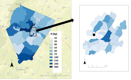
The Community Nitrogen Footprint Tool (C-NFT) project focuses on expanding the scale of the nitrogen (N), greenhouse gas (GHG), and phosphorus (P) footprint calculations beyond the scope of the university. The tool uses publicly available data from both local utilities and the census to determine the spatially explicit footprints of a community by census block group. In the past, calculations have been done for Baltimore City (Dukes et al., 2020) and Charlottesville City (Staganelli et al., 2020). During the past semesters, our team has been working to adapt and make additions to the C-NFT frame to calculate the N footprint of Albemarle County. To do this, we are working to add crops, livestock, airports, and septic systems to the framework. These additions will help to fully evaluate the N losses within the county. We have also added P and GHG footprints to the analysis as well as evaluated the environmental impact of strategies in the three entities’ (Charlottesville City, UVA, and Albemarle County) action plans. Below is an image of the Albemarle County and Charlottesville City N footprints.
For more information, contact Libby Dukes at esm9gq@virginia.edu
.